The Chicago Map Society typically meets at The Newberry Library on the third Thursday of every month during the academic year (September through May). Meetings start at 5:30 pm with a social half-hour, followed by an hour presentation on a cartographic subject of interest to our membership. Our meetings are open to the public, but to help defray expenses, non-members are asked for a small donation at the door. If you are unfamiliar with The Newberry, which is located on the near northside of Chicago, here are directions.
Please note that in May 2022, the Chicago Map Society began live streaming its programs to the web. Access to these programs is free of charge, but advance registration is required.
Upcoming CMS Events at The Newberry Library
Date: Thursday, May 16th, 2024
Location: Ruggles Hall, Newberry Library/Zoom Presentation Online
Time: 5:30 pm CT (Social Time)/6:00 pm CT (Presentation)
Title: Games on Maps
Speaker: Wilbert Stroeve
Description: Remember Risk? It was probably the first time that I ever heard of geographical regions called Yakutsk and Irkutsk. Over the years I have played many board games and now that I am retired I have time for more. It was suggested to do a map talk about those games that involve maps (as we would commonly describe them). And playing games such as Risk, Rail Baron, Civilization, Settlers of Catan, etc. involve a map-like board. I explore some of the early history of board games and continue on to those that would resemble a map.
Speaker Bio: Born in The Netherlands, immigrated with family to CA when 8 years old in 1959. Drew maps in 1st & 2nd grade. After graduating from University, moved back to NL for a programming job. Afterwards moved to CA and on the way stopped off in the Chicago area for a job interview and got the job! Member of CMS since 1990s. Served on the board numerous years; President of CMS for ~4 years when IMCOS & Nebenzahl lecture took place at the Newberry.
Upcoming Off-Site Events
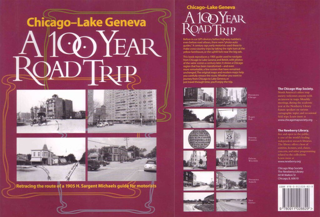
Chicago – Lake Geneva: A 100-Year Road Trip
Retracing the Route of H. Sargent Michaels’ 1905 Photographic Guide for Motorists
-Presentation by Wilbert Stroeve

Copies of this wonderful book are available for $15 at the following in-person events:
Date: Sunday, April 28th, 2024
Location: Antioch Senior Center | 817 Holbek Drive | Antioch IL | Google Maps
Time: 1:00 pm CT
Title: Chicago-Lake Geneva | A 100 Year Road Trip
Speaker: Wilbert Stroeve
Date: Saturday, June 15th, 2024
Location: McHenry County Historical Society | 6422 Main Street | Union IL | Google Maps
Time: 1:00 pm CT
Title: Chicago-Lake Geneva | A 100 Year Road Trip
Speaker: Wilbert Stroeve
Date: Sunday, July 21st, 2024
Location: Wilmette Historical Museum | 609 Ridge Rd | Wilmette IL | Google Maps
Time: 1:00 pm CT
Title: Chicago-Lake Geneva | A 100 Year Road Trip
Speaker: Wilbert Stroeve
Description: In 1905 Homer Sargent Michaels, an automobile agent based in Chicago, developed an unusual solution to one of the thorniest problems facing early motorists: how to find one’s way from one city to another along the poorly marked rural roads of the time. Michaels’s solution was to take photographs of every major intersection or turning point along a given route. The resulting books—ancestors of today’s digital in-car navigation systems—were remarkably useful, but few copies survive.
Now the Chicago Map Society, in collaboration with the Newberry Library, has compiled a new edition of one of Michaels’s 1905 guides showing the route from Chicago to Lake Geneva, a resort town in southern Wisconsin. This new edition reproduces the entire guide, along with brief explanations and new photographs of the same locations today, as well as an introduction by the Newberry Library’s curator of maps, Robert W. Karrow Jr. Chicago to Lake Geneva: A 100-Year Road Trip is a stellar presentation of a historical artifact—and a fascinating drive down memory lane.
You can also purchase this book online via The University of Chicago Press website.
